Doctoral Work:
Advisors: Marina Astitha and Diego Cerrai
My doctoral work is supported by a NASA FINESST Fellowship and the Eversource Energy Center and with much of my research focuses on winter weather through the use of observations, instrumentation, and numerical modeling. I also spend time working on improving machine learning models to predict weather-related power outages. Below are a summary of the main research projects I have been working on.
NASA FINESST: Refinement of Snow Microphysics and Density Forecasting Using GPM Ground Validation Observations and NU-WRF
Proposal Summary:
This proposal’s key objective is to test and refine NASA’s high resolution weather modeling capabilities of winter storms through utilizing its ground validation instrumentation from Global Precipitation Measurement (GPM) mission deployments. Forecasting snow amounts is a difficult problem because it requires understanding of how much liquid water of snow will occur in one location and then converting it using the snow’s density to get a snowfall amount. While many methods have been tested previously, there has not been a significant advancement in the last 10 years and many of these methods rely on environmental conditions rather than physical processes. To improve upon this, physical processes occurring in the microphysics schemes in numerical weather simulations guided by GPM ground instrumentation can help inform a physically based approach to forecasting snow density, which will ultimately help snowfall forecasts.
To accomplish this, field observations of snow microphysics will be used from up to 4 different GPM ground validation missions in the mid-latitudes. Instrumentation for observations will include ground-based radars, weighing rain gauges, laser and video disdrometers which will provide information about precipitation amount and rate, particle size and fall speed, and atmospheric conditions of the lower atmosphere. These observations will first be used to validate NASA’s Unified Weather Research and Forecasting model (NU-WRF); this validation will include a set of experiments testing how different microphysics schemes within NU-WRF represent precipitation amounts and structure.
Upon learning about NU-WRF’s sensitivities and the generation of accurate simulations, focus will be given to NASA’s Goddard microphysics scheme, which will be used in the NU-WRF simulations. The Goddard microphysics scheme is an important component of numerical weather simulations as it parameterizes the different types and amounts of hydrometeors in each grid cell of the simulation. To parameterize snow hydrometeors, the Goddard scheme applies several key relationships like a snow size density mapping, diameter fall speed relationship, and mass-diameter relationships; these assumptions have not been validated in winter campaigns before. Validation of these relationships will occur using ground instrumentation such as the Precipitation Imaging Package (PIP), a NASA design video disdrometer. Upon verification of these relationships, adjustments and refinements may be needed, and if so, they will be implemented.
The refined Goddard microphysics scheme can be used as the basis for the explicit snow density forecast. The goal will be to apply different techniques with physical basis to forecast snow density. This will include the application of solving for the quantity using the prognostic variables within the model, physically based post processing algorithms and artificial intelligence. The explicit snow density algorithm will be validated both against the PIP’s density measurements, as well as manual observations from humans.
This work will align with NASA Earth Science Division’s goal to improve weather and air quality forecasts and prediction of extreme events. Improving snow microphysics will aid models to resolve winter storms better, and while the focus is on NASA modeling components and observations, the work will impact multiple agencies besides NASA. Also, the use of ground instrumentation from NASA field campaigns will provide new applications for some of the instruments, like the PIP. By learning more about the physical processes the govern snow properties, they can be applied to other areas of NASA research like satellite operations and algorithms. Overall, this proposed project’s main goal is to validate both NASA modeling systems and components using ground observations collected by NASA instrumentation and use the findings to develop a new, physically based method of forecasting snow density.
 Winter Precipitation Measurements in New England: Results from the Global Precipitation Measurement Ground Validation Campaign in Connecticut
Abstract:
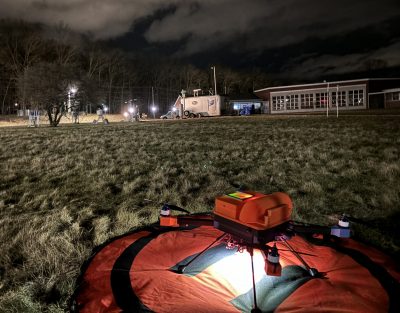
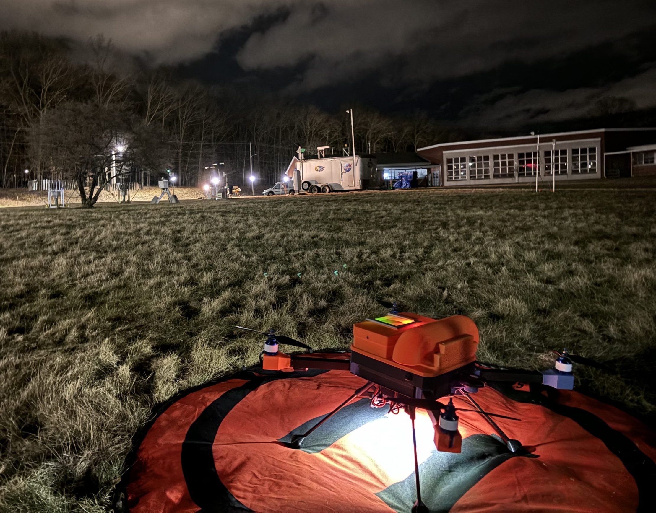
Winter precipitation forecasts of phase and amount are challenging, especially in Northeast United States where mixed precipitation events from various synoptic systems frequently occur. Yet, there are not enough quality observations of winter precipitation, particularly microphysical properties from falling snow or mixed phase precipitation. During the winters of 2021–2022, 2022–2023, and 2023–2024, the NASA Global Precipitation Measurement (GPM) Ground Validation (GV) program conducted a field campaign at the University of Connecticut (UConn). The goal of this campaign was to observe various phases of winter precipitation and winter storm types to validate the GPM satellite precipitation products. Over the three winters at UConn, a total of 40 instruments were deployed across two observing sites that captured 117 precipitation events, including 19 phase transition events as indicated by the PARSIVEL2. These instruments included scanning and vertically pointing radars, along with suites of in-situ sensors. In addition, an unmanned aircraft system has been deployed in 2023–2024. Here, an overview of the different field deployments, instrumentation, and the datasets collected are presented. To showcase the observations, this article features a wide-ranging set of measurements collected from the instrument suite for the 28 February 2023 storm, during which six to eight inches of snow accumulated at the two different observing sites. Also included is a discussion on how these observations can be combined with other datasets to validate ground-based and remote sensing measurements and highlight important atmospheric processes that impact winter precipitation phase and amount.
Highlighted Publications and Presentations:
Preprint Under Revision in Earth System Science Data: https://essd.copernicus.org/preprints/essd-2025-162/
AMS Annual Meeting (January 2024): Slides
A 5-year Evaluation of Radar Quantitative Precipitation Estimates during the Cool Season
Abstract:
Wintertime precipitation measurements present many challenges as changes in phase and intensity can occur over very small distances. Additionally, not all precipitation gauges can obtain accurate measurements during freezing temperatures or frozen precipitation. While weather radars are not subject to these issues, they have their own set of challenges including beam coverage and blockage, and application of the correct Z-R or Z-S relationships. Gridded precipitation products are commonly used to validate numerical weather model precipitation forecasts, but during the wintertime, concerns over the quality of these products raise questions of when they can be used. Here, two gridded radar-derived, gauge-corrected quantitative precipitation estimate products, Stage IV and MRMS Multi-Sensor Pass 2, were compared to 85 ASOS stations with weighing precipitation gauges, the standard for measuring all forms of winter precipitation, across the Midwest and Northeast United States. The products were evaluated over three different accumulation periods, 1, 6, and 24 hours, spatially divided by NWS River Forecast office, and observed precipitation phase at the ASOS stations. The results from this work indicated that Stage IV performed better overall compared to MRMS over all accumulation periods, and both products performed better over longer accumulation periods. However, the efficacy of the products varied spatially with Stage IV having a pronounced regional division due to its processing procedure. Focusing on precipitation phase, MRMS performs better for liquid precipitation, whereas Stage IV performs better for mixed or frozen precipitation. These results can be used by modelers to better apply these datasets in validation settings.
The Efficacy of Ten Snow-to-Liquid Ratio Algorithms to Predict Snowfall for Impactful Winter Storms in the Northeast United States
Abstract:
Predicting snowfall accumulations is not a straightforward task due to it requiring multi-step process and predicted variables from numerical weather model output to be accurate and the scarcity of quality observations for evaluation purposes. However, snowfall serves as a measure of how impactful a winter storm can be, in conjunction with the density of snow accumulated on the ground, power lines, trees, and rooftops. Here, 10 different snow-to-liquid ratio (SLR) algorithms are applied to consistent precipitation output from the Weather Research and Forecasting model for 14 impactful snowstorms in the Northeast United States. The SLR algorithms are evaluated against the gridded National Snowfall Analysis product for event total snowfall accumulations. The results from this work showed that performance of the SLR algorithms varied depending whether or not biases in forecasted precipitation were considered. When exploring the impact of temperature on the SLR algorithms, it was found that colder temperatures had more variability in the forecasted SLR compared to warmer temperatures, where the range in SLR values was narrower. This result was important because the average surface temperature is commonly used to quickly estimate what the likely range of SLRs will be. Across all the different comparisons involving the SLRs, the methods that produce the most consistent results were ones that utilized temperature, or atmospheric thickness, above the surface. The results from this work can be used as a baseline comparison for applications in future studies evaluating SLR methods.
Highlighted Publications and Presentations:
Under Review in Weather and Forecasting
Assessing Dynamic and Thermodynamic Variability in Initial and Boundary Conditions for Snowstorm Prediction in the Northeast United States
Abstract:
Winter storms present significant hazards across the Northeast United States, often disrupting daily life. Numerical modeling of these storms is an important component for understanding the physical processes that cause significant impacts and for predicting their effects ahead of time. Initial and boundary conditions are an essential component to limited-area modeling; variability in these conditions can significantly alter the simulations. While previous modeling studies have investigated sensitivities in model physics, there has been limited exploration of the impact of different initial condition sources; differences within these sources can include horizontal and vertical resolution, data assimilation schemes, and domain. This study aims at identifying the sources of variability from the initialized atmospheric fields within four different sets of initial conditions and their impact on the prediction of winter precipitation processes. The key finding was that relative humidity across different initial and boundary conditions produced the most uncertainty on the model simulation, while variability in temperature or synoptic conditions had a minor role. To explain the precipitation differences seen during the simulations, vertical profiles of relative humidity and temperature were connected to microphysical hydrometeor species tracked within the model. The findings suggested that relative humidity differences are heavily linked to precipitation accumulation discrepancies and were the main source of variability from the initial conditions. These results call for the development of more accurate relative humidity profiles for model initial and boundary conditions.
Highlighted Publications and Presentations:
Under Revision in JGR: Atmospheres
AMS Annual Meeting (January 2025): Slides
UConn Outage Prediction Model
Abstract:
When high impact storms occur, millions of people lose power in the densely populated and vegetated northeastern United States. Developing models for predicting the number and location of power outages and their estimated restoration time helps the utility providers, residents, and federal government save hundreds of millions of dollars for each major storms and contributes to reducing the consequences of prolonged outages.
In conjunction with Eversource Connecticut, the University of Connecticut Outage Prediction Model (UConn OPM) was developed over the last 10 years. It consists of four modules, one for each major storm type or severity: (i) thunderstorms, (ii) extratropical, (iii) tropical, and (iv) winter storms. The OPM has been continuously improved over time, and now has been extended to four major utilities across eleven states in the Eastern United States. In this presentation, an overview of outage prediction modeling will be presented, with a focus on the key components for model development. Model performance will then be compared across service territories, with an emphasis on the Eversource service territory located in Connecticut, Massachusetts, and New Hampshire. Lastly, the role of information from and communication with the NWS will be discussed as it relates to conveying the potential outage forecasts to utility operators.
Highlighted Presentations:
Northeast Regional Operation Workshop (November 2023): Slides

Master’s Work:
Thesis Topic: Probabilistic Forecasting of Winter Mixed Precipitation Types in New York State Utilizing a Random Forest
Advisors: Kristen Corbosiero, Andrea Lang, Nick Bassill, and Ross Lazear
Project Overview:
My master’s work was supported by a NOAA Collaborative Science, Technology, and Applied Research (CSTAR) program between the National Weather Service (NWS) and the University at Albany. The focus of my research was implementing machine learning techniques on large datasets to help improve the forecasting ability of winter mixed precipitation events. In addition to combining machine learning with big data, my project also consisted of an operational component; through collaboration with NWS Albany forecasters, I created an operational tool to help them with forecasting winter mixed precipitation events.
Abstract of Master’s Thesis:
Operational forecasters face a plethora of challenges when making a forecast; they must consider multiple data sources ranging from radar and satellites to surface and upper air observations, to numerical weather prediction output. Forecasts must be done in a limited window of time, which adds an additional layer of difficulty to the task. These challenges are exacerbated by winter mixed precipitation events where slight differences in thermodynamic profiles or changes in terrain create different precipitation types across small areas. In addition to being difficult to forecast, mixed precipitation events can have large-scale impacts on our society.
To aid forecasts for these events, the goal of this thesis is to take the multiple data sources used by forecasters and combine them together using machine learning to improve forecasting ability for mixed precipitation events. The expectation is that by employing a machine learning framework, forecasters will have more time to spend analyzing the most difficult portions of the forecast.
In order to achieve this goal, Community Collaborative Rain, Hail and Snow Network (CoCoRaHS) daily observations from trained reporters between January 2017 to September 2020 were used to identify precipitation events that included rain, snow, freezing rain, and sleet. The data associated with the timing of these mixed precipitation events were collected from the New York State Mesonet, National Weather Service upper air soundings, High-Resolution Rapid Refresh model (HRRR), and North American Mesoscale forecast model with a nested domain (NAMNEST). A random forest (RF) machine learning algorithm was trained and tested on cases identified from the CoCoRaHS reports that were matched with the meteorological datasets. Internal testing identified the best combinations of meteorological variables and data sources to make operational forecasts with.
An operational website was developed to display the products made with the output of the RF. The website was operational in real-time during the 2021-2022 winter season, and the RF was also run to create the same products for the 2020-2021 winter season. This was done to increase the sample size of the forecast guidance to do verification on. Verification was completed for the winters of 2020-2021 and 2021-2022 by using ASOS and mPING observations as ground truth. Results from the verification process gave a positive indication that certain products can provide accurate precipitation type forecasts to be employed in combination with analysis by an operational forecaster during winter mixed precipitation events. The operational products were expanded for the winter of 2022-2023, and the operational website currently has five operational forecasting tools, four of which provide probabilistic winter precipitation type forecasts for rain, freezing rain, sleet, and snow.
To learn more about this project and view the website, please click here: Albany Data Fusion Winter Weather AI Project
Highlighted Publications and Presentations :
Filipiak, B. C., N. P. Bassill, K. L. Corbosiero, A. L. Lang, and R. A. Lazear, 2023: Probabilistic Forecasting Methods of
Winter Mixed Precipitation Events in New York State Utilizing a Random Forest. Artif. Intell. Earth Syst., 2,
https://doi.org/10.1175/AIES-D-22-0080.1.
WPC Winter Weather Experiment (December 2021): Slides
AMS Annual Joint Conference with the 31st Conference on Weather Analysis and Forecasting (WAF)/27th Conference on Numerical Weather Prediction (NWP) and 21st Conference on Artificial Intelligence for Environmental Science (January 2022): Slides
Master’s Thesis Presentation (December 2022): Slides
Other Select Projects:
Completed:
Winter Precip Type Research Multi-Scale Experiment (WINTRE-MIX) – February and March 2022
Advisor: Justin Minder (UALBANY)
Summary of Field Work:
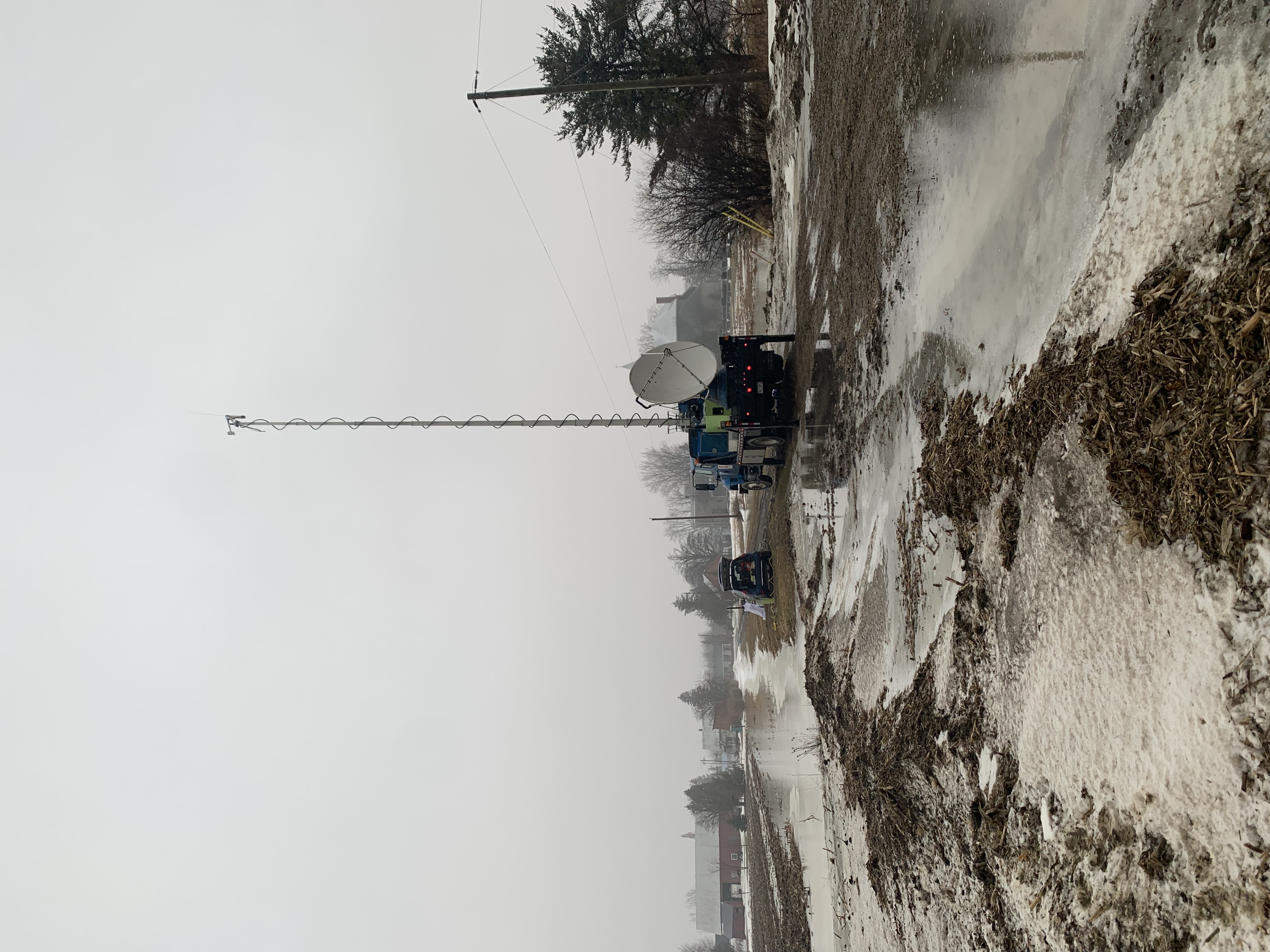
I participated in the WINTRE-MIX Field Campaign located in the St. Lawerence and Champlain valleys. This field study’s goal was to improve the understand and prediction of precipitation types that occur in near freezing conditions on the synoptic, mesoscale, and microscale, especially in areas of complex terrain which is abundant in the domain of interest.
My involvement in the field operations was working on collecting ground based observations to supplement the existing mesonet networks and aircraft observations during Intensive Observing Periods (IOPs). On the ground, I collaborated with scientists from the University of Colorado and the University of Illinois at Urbana-Champaign Flexible Array of Radars and Mesonets to collect precipitation type observations, upper air profiles from radiosondes, and radar data from DOW6, DOW7, and COW radars. Over the 6 week period, I participated in 7 of the 11 IOPs during all hours of the day and night; during the IOPs, I helped with over 20 successful radiosonde launches, collected precipitation type observations every 10 minutes, took macro-photographs of frozen precipitation, and assisted with radar operations.
Videos and News Articles:
UAlbany Video Summary, UAlbany Article

Renewable Energy Droughts: An Analysis of Renewable Energy Droughts in New York State between 2018 and 2022
Advisors: Jeff Freedman and Richard Perez (UALBANY)
Project Overview:
As part of my Renewable Energy Issues graduate course, I conducted an analysis of renewable energy droughts at 3 locations in New York. This project was expanded to include 17 NYS Mesonet Profiler locations as well as offshore wind data. The goal was to examine when and for how long do renewable energy droughts occur in New York. Through analysis of Lidar data and insolation data from Solar Anywhere, the data was processed, and periods of underperformance were noted. We have 2 key definitions of droughts: 1) Energy Production Drought: A period where an energy resource’s daily capacity factor is less than its averaged capacity factor for that location or region regardless of season; and, 2) Renewable Energy Drought: A period where multiple renewable energy resources experience an energy production drought at the same time.

NSF REU Texas A&M: Diurnal and Spatial Variability of Tornadogenesis and Forecasting in Tropical Cyclones – June and July 2019
Advisor: Chris Nowotarski (Texas A&M)
Abstract:
Landfalling tropical cyclones generate many hazards like storm surge, wind damage, heavy rainfall totals, potential for flash flooding, and tornadoes. Forecasting these multiple events is problematic as forecasters are unable to focus on just one type of hazard. Given this and less clarity in the environmental parameters and radar attributes of the cells that produce them, there is often a high false alarm rate for tornado warnings within tropical cyclones. To improve the ability to forecast tornadoes in these unique conditions, understanding the relative location and timing of tornadic events is key. Additionally, identifying differences in the near-storm environmental conditions associated with tornadic and nontornadic cells and their spatial and temporal variability is expected to yield more accurate forecasts.
Using storm reports and radar data, cells were identified as tornadic or non-tornadic, and tornadoes were identified as warned or non-warned for all landfalling US tropical cyclones in the 2018 season. Soundings of the near-storm environments for each cell were gathered from Rapid Refresh (RAP) numerical model analyses, from which relevant convective parameters were calculated and compared. This analysis showed there was a clear diurnal cycle in tropical cyclone tornadoes, as there was a peak in tornado frequency in the late afternoon. The results revealed how changes in the near-storm environment contributed to the diurnal cycle in tornadoes. These same parameters were examined spatially and showed patterns of change relative to time after landfall and distance from the tropical cyclone center. Finally, variability in forecasting skill scores (both spatially and temporally) relative to the diurnal cycle and tropical cyclone position were examined.
Highlighted Presentation:
AMS 19th Annual Student Conference Poster Session (January 2020): Poster